Archaeological Briefing and Testing Plan Powder Magazine Block 12 Building 9
Colonial Williamsburg Foundation Library Research Report Series - 0137
Colonial Williamsburg Foundation Library
Williamsburg, Virginia
1990
ARCHAEOLOGICAL BRIEFING AND TESTING PLAN
BLOCK 12
POWDER MAGAZINE
Prepared for
The Magazine Interpretive Planning Team
July 9, 1985
| Introduction | 1 |
| Current Property Appearance | 1 |
| Map Research | 1 |
| Prior Archaeological Investigations | 6 |
| Other Disturbances to the Property | 12 |
| Archaeological Potential | 19 |
| Bibliography | 22 |
| Appendix A | 25 |
| Appendix B | 26 |
| Figure | 1. Current Property Appearance | 2 |
| 2. Frenchman's Map of 1781 | 3 | |
| 3. Detail of the Frenchman's Map | 4 | |
| 4. Rochambeau Map | 5 | |
| 5. Block 12 Archaeological Areas | 7 | |
| 6. Excavation of the Magazine Wall (1933) | 8 | |
| 7. Block 12 Archaeological Features | 9 | |
| 8. Block 12 Disturbances | 13 | |
| 9. 1850 Baptist Church | 15 | |
| 10. Bell Hospital | 16 | |
| 11. Tunnel Construction (1940/41) | 17 | |
| 12. Area Impacted by the Tunnel Construction | 18 | |
| 13. Block 12 Archaeological Potential | 20 |
Introduction
This archaeological briefing and testing plan has been prepared for the Magazine Interpretive Planning Team. Its purpose is to analyze the property in terms of previous disturbances to archaeological resources, usually in the form of early archaeological investigations and post-colonial building episodes. The resources used in the preparation of this document included 18th and 19th century map information, Colonial Williamsburg research and archaeological reports, historic photographs, and archival material pertaining to the property.
Current Property Appearance
The Powder Magazine and its associated outbuildings are located in Market Square on Block 12. The property is bordered to the north by Duke of Gloucester Street, to the south by Francis Street, to the east by the Market Square Tavern property, and to the west by the Greenhow-Repiton property (Figure 1).
The Powder Magazine is an original building which has been restored through the efforts of the APVA and the Colonial Williamsburg Foundation. Archaeological investigations of the property have provided information for the reconstruction of the high brick wall enclosing the Magazine, and that of the guardhouse located to the southeast. A path leads from the door in the northern facade of the Magazine to Duke of Gloucester Street, with two sentry boxes flanking the path.
Map Research
Frenchman's Map The Frenchman's Map of 1781 shows three structures in association with the Powder Magazine. These are shown in Figures 2 and 3.
Rochambeau Map A Rochambeau Map from the late 18th century also shows three structures located to the east of the Powder Magazine (Figure 4).
Bucktrout Map The Bucktrout Map, dating to the beginning of the 19th century, only shows the Magazine standing in the center of Market Square. This map, however, only showed major structures, and probably would not have included the ancillary buildings.
2
 Figure 1. Current Property Appearance
 Figure 2. Frenchman's Map of 1781.
Figure 3. Detail of the Frenchman's Map
Figure 4. Rochambeau Map
There are also numerous illustrations and photographs of the Magazine, dating from the 19th century to the present. These sources help document changes to the property over time. A list of these sources is provided in Appendix A.
Prior Archaeological Investigations
Archaeology was conducted in the vicinity of the Powder Magazine in 1933, 1934 and 1948 in Archaeological Areas B and C (Figure 5). These separate excavations will be described below.
In January of 1933, excavations at the Powder Magazine (Block 12, Archaeological Area B) had been completed under the direction of Herbert Ragland. Photographs of this excavation show trenching to expose the remnants of the wall which had surrounded the magazine, but the remainder of the interior Magazine yard appears undisturbed (Figure 6). This wall was reconstructed in 1935. Archaeology indicated a brick path between the wall gate and the north entrance and no other paths were indicated in this enclosure (Kendrew 1935). The excavations also located a "modern" well just inside the Magazine wall, directly west of the northern entrance. This well was most likely associated with the Magazine's use as a livery stable.
A cache of over 300 cannonballs was located 10' south of the Magazine wall, and photographs suggest that portions of this feature were not excavated in 1933. James Knight, who worked on the project, remembers that part of the feature was left untouched, and is most likely still extant underground (Knight 1985). Apparently the cannonballs were presented to the APVA in April of 1936 in exchange for some other items (Goodwin 1936). T. R. Goodwin, in a letter to A.P.V.A. member Mrs. A. D. Jones, stated that he planned to clean the cannonballs in a concrete mixer.
After locating the wall surrounding the Magazine, further archaeological excavations were conducted in the latter part of 1934 in an attempt to locate the Guardhouse. The Frenchman's Map of 1781, depicting structures to the east of the Magazine was used to plan the areas excavated. Figure 7 shows archaeological features uncovered in this excavation in relation to information from the Frenchman's Map. The report for this excavation has not been located, but the map contains a sizeable text portion which describes the foundation located through the investigation. Three structures were located and these are described below.
7
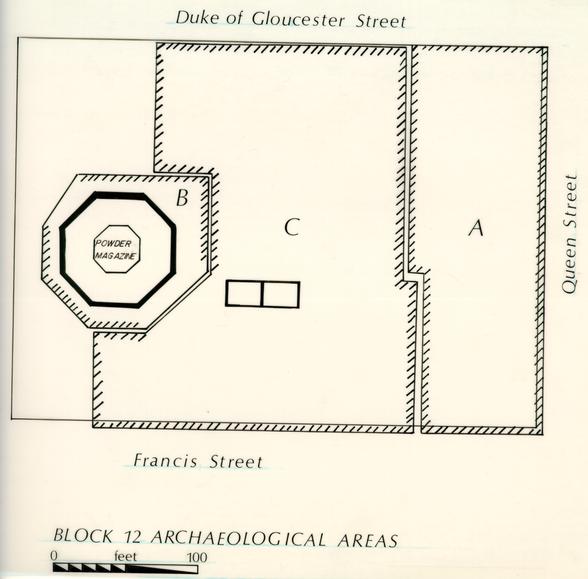 Figure 5. Block 12 Archaeological Areas
 Figure 6. Excavation of the Magazine Wall (1933)
 Figure 7. Block 12 Archaeological Features
Structure E
This structure, according to the archaeological map, was located near the existing ground surface. A date for its construction was given as the "colonial" period on the basis of the workmanship, shell mortar and Flemish bonding of the foundation. The structure measured 62' 8" EW by 22' 9" NS, with walls 1' 1" in thickness and averaging four courses in depth. There were no photographs of the excavation of this structure, but most likely it was located through trenching. In this event, the builder's trenches for the building would probably be destroyed by the trenching, virtually eliminating any chance of dating the building's construction. Chances are good however, given the past experience of this department, that stratigraphic layers of fill are still present within the interior of the structure, and these may furnish some clues about dating the building's construction and demolition. Generally, after archaeological excavations were completed, structural foundations were recovered with soil unless the building was going to be reconstructed. Therefore, it is highly likely that the foundations for Structure E are still in place.
Structure G
The 1934 excavations also revealed the brick foundations of a large (60' NS by 40' EW) structure to the northeast of the Magazine. About half of the brick foundation was still intact, with the western portion of the building discernible as a concentration of brickbats. Examination of the brickwork revealed that neither the bonding nor the mortar used were of "colonial character" (Campbell 1934a). Since no local residents had a recollection of this structure and a fully grown tree was growing over the north wall the archaeologists and architects concluded that the structure was built early in the 19th century. This was originally city property and in 1934 it was felt that this structure most likely represented a public building of some kind.
Structure H
Structure H represents the fragmentary foundations of a building interpreted as belonging to the "colonial period" (Campbell 1934a). The brick foundations of this structure were located at a depth below grade similar to that of the Magazine. The complete size of the structure could not be ascertained due to previous damage to the brick foundations. It was approximated that the structure measured 28'10" EW by 19'3" NS. Located in the general area shown to contain a building on the Frenchman's Map, the foundations were interpreted as the guardhouse.
The interior of the Magazine was also excavated during the 1934 work. In order to conduct these excavations, the cement floor, which 11 had been installed by the APVA, was removed. The interior of an inner brick octagon was completely removed, but other areas inside were only excavated down to a brick paving. Also, three feet of fill along the south, west, and east walls of the Magazine were never disturbed. After these excavations were completed, a new concrete slab floor was installed (Moorehead 1946).
In 1948, Archaeological Area C was cross-trenched in a northeast to southwest direction. This cross-trenching located the foundations of another building, similar in form to the structure located in the 1934 excavations and identified as a guardhouse. The structure uncovered in 1948 was located east of the Powder Magazine, and south of the 1934 structure. Traces of another building, congruent with the Frenchman's Map were also uncovered in 1948. These are described below and can be seen on Figure 7.
Structure F
The 1948 excavations on Block 12 revealed the remains of a structure located slightly southeast of the Magazine. This is the building which has currently been reconstructed as the Magazine guardhouse. The structure had been partially robbed of its brick foundations, but it appeared that the building had been constructed in two stages, each during the "colonial" period (Knight 1948). Only the first period of construction has been reconstructed as the guardhouse.
Structure I
These probable structural remains were composed of an east-west running line of brick bats and shell mortar. Located approximately 1' below grade, they are seen in Figure 7 as located in an area shown to contain a structure on the Frenchman's Map. As with all the other structures located through archaeological excavation, there are no records of any artifacts provenienced to specific structures to aid in their dating.
Landscaping in connection with the construction of the guardhouse took place in 1948. This included grading, installation of gravel paths, removing an existing culvert and building a new culvert, and removal of a brick path (Jones 1948).
Colonial Parkway Tunnel Prior to the tunnel construction, money was appropriated for archaeological excavation along the tunnel corridor. Records suggest that the only area which was examined during this period was on the Skillman and Miller property on Block 28. There is no indication that any archaeological work was conducted on Block 12 in the vicinity of the Powder Magazine.
12No archaeological work has been undertaken north, northwest, west, or southwest of the Magazine.
Other Disturbances to the Property
In addition to disturbances created through previous archaeology, later building episodes on Block 12, plus landscaping in connection with the Colonial Williamsburg restoration, must be taken into account. Following are descriptions of each of the structures which were known to have stood on Block 12 in the vicinity of the Powder Magazine. Their location and probable impact on archeological resources pertaining to the magazine is examined (Figure 8).
Buildings 1 & 3 Building 1 was an eight room frame bungalow located on the north side of Francis Street, between South England and South Queen Streets. During the 1930s it was used by the Chesapeake and Potomac Telephone Company as a telephone exchange office. Correspondence dating to the period when C & P occupied the building indicates that there were large amounts of cable laid in connection with the building's use as an exchange office (Lecky 1929). These quarters were vacated by the telephone company at the end of August, 1934 and wrecked within 21 days (Geddy 1934). Specifications for the wrecking of the building indicated that the brick foundations were to be removed. Building 3 was a garage associated with the telephone exchange.
Buildings 2 & 4 The property where these buildings were located was the northeast intersection of Francis and England Streets, directly in the rear of the Bell Hospital. These structures were referred to as "Negro Shacks" in 1930, just prior to their wrecking (WHC 1930). Photographs of the structures shows that both were pier-supported and would have caused little damage to archaeological features in that area. Correspondence indicates that the two buildings were in very poor condition in 1930, with neither having electricity, heat or plumbing. Nevertheless, the houses continued to be occupied by black tenants up until the time they were demolished in December of 1930 (WHC, 11-26-30) . These houses appear to have fronted on South England Street.
Building 14 Spencer and Dana Real Estate Office This two story frame structure was located east of the Stone Store (A & P). It rested on a brick foundation, and was wrecked in April of 1931.
Buildings 15 & 19 Stone Store The Stone Store, leased by the A & P as a grocery, was located east of the Baptist Church parsonage. This was a frame structure on a brick foundation, and associated with it was a small outbuilding, in poor condition according to a 1930 description of the property. Records seem to indicate that the store
13
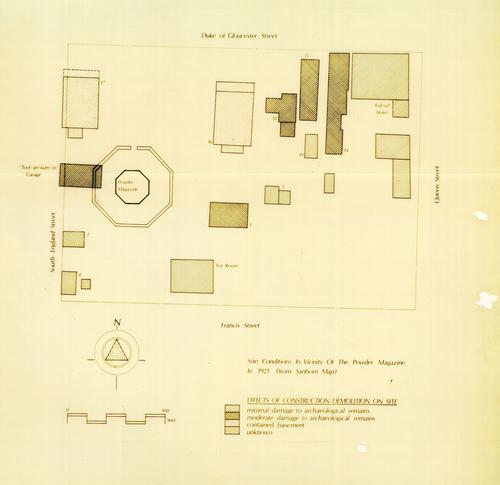 Figure 8. Block 12 Disturbances
14
had been used by the A & P since around 1912 (Stone Store 1928-1934). The two buildings were demolished in 1934 (Memo 1934).
Figure 8. Block 12 Disturbances
14
had been used by the A & P since around 1912 (Stone Store 1928-1934). The two buildings were demolished in 1934 (Memo 1934).
Buildings 16 & 18 Baptist Church The Baptist Church, located northeast of the magazine, was constructed in 1850. It is believed that the church was at least partially built with bricks salvaged from the wall surrounding the Magazine. When reconstruction of the wall was planned in the 1930s, a question was posed about whether the bricks in the basement of the church were from the original wall and if there would be enough there to rebuild the wall (WHC 1933). The old brick turned out to be unusable, and new brick were fired. The Williamsburg Holding Corporation bought the church in 1933, and it, along with the parsonage, was wrecked in July of 1934 (Todd and Brown 1934). Photographs of the church show that its appeared to have a half basement, which would incur damage to archaeological resources in that area (Figure 9).
Building 17 Williamsburg or Bell Hospital The Bell Hospital, located northwest of the magazine was a 3 story brick building. This building was constructed in the 19th century, and was wrecked in November 1930 (Shurcliff 1930). Photographs show that the structure contained a basement, at least under the northern end of the building (Figure 10) . A fence divided the hospital property from that of the Magazine (Geddy 1931). Records indicate that topsoil was hauled to the site of the Bell Hospital after its removal.
"Toot-an-kum-in" Garage This structure stood directly to the south of the Bell Hospital and can be seen on the 1921 Sanborn Map. Its foundations cut and damaged the brick enclosing wall of the Magazine.
Colonial Parkway The Colonial Parkway tunnel, constructed in 1940/41, passes directly through Block 12. Specifications called for the construction of a reinforced concrete tunnel .517 miles in length. The tunnel was to be built by the "cut and cover" method, involving the excavation of 110,700 cubic yards of earth (Tunnel 1937-39). Figure 11 shows the amount of soil disturbance which was involved with this construction. Topsoil was to be placed over the area disturbed by the tunnel, and landscaped to match the former grades. There is no archaeological potential for the area impacted by the tunnel (Figure 12).
15
 Figure 9. 1850 Baptist Church
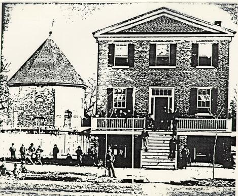 Figure 10. Bell Hospital
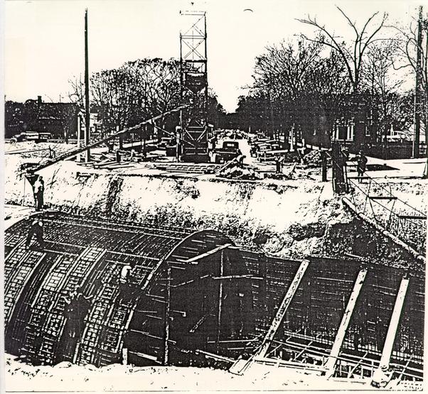 Figure 11. Tunnel Construction
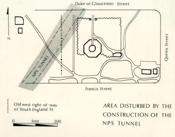 Figure 12. Area Impacted by Tunnel Construction
Archaeological Potential
Figure 13 shows probable archaeological potential for Block 12, based on the background research covered in this report. Archaeological Area 12B was apparently only excavated in areas where the architects felt they would locate information on structural elements. Therefore, some substantial areas within B do not appear to have been disturbed at all, for example, the interior of the Magazine yard. Also, the outlines for the cannonball cache were not recorded in 1933, and there is a possibility that there may be a structure associated with this feature. These areas are marked in Figure 13 as having good archaeological potential for yielding information on activities around the Magazine.
Area 12C was cross-trenched and the coverage appears to have been fairly good, so no more brick foundations should be expected in this area. Archaeological cross-trenching consisted of placing 1' wide trenches spaced 5' to 6' apart at a 45 degree angle to the property and street lines. This insured that all structures with brick foundations would be located. Cross-trenching does not, however, destroy all valuable archaeological information. Subsequent archaeological investigations in this area could be used to locate traces left by impermanent types of structures, patterns of postholes associated with fence lines and refuse deposits on the property.
We can anticipate the remains of the huge 1850 Baptist Church in the northeast corner of the Magazine lot, and also the remains of the Bell Hospital in the area just north of the Magazine. Figure 14 shows both these structures, along with a number of other buildings west of the Magazine, which should have left archaeological traces and may have destroyed archaeological remains. The areas where the basements of the church and the hospital are expected have no archaeological potential, but the remainder of the structures on the lot are estimated to have left little or no damage to archaeological remains.
There is moderate archaeological potential for most of the structures which were investigated during the prior excavations. Excavation usually only uncovered the foundations of the buildings, and left interior fill virtually untouched. Therefore, reopening of these structures could furnish information on the function and dating of these buildings.
The artifact collection from the previous excavations is apparently provenienced only to two very large areas. Data collected in this manner cannot be used to answer current research questions, so the artifact assemblage is of little use. However, we can probably assume that the over 300 cannonballs all came from the sealed cache and have some research value.
20
 Figure 13. Block 12 Archaeological Potential
Appendix B is a proposal for a testing plan at the Powder Magazine. The testing is proposed in two parts, the first being an preliminary survey to see if landscaping on the property has removed all the 18th century cultural fill. The Phase II testing plan is designed to answer specific questions about the property which could aid in the interpretation of the Magazine.
Bibliography
- 1800
- Plan of the City of Williamsburg. Map on file, Colonial Williamsburg Foundation, Research Department Library.
- 1934
- a Archaeological Survey of Foundations Surrounding the Magazine. Foundations in Block 12-12C.
- 1934
- b Archaeological Survey of Foundations Inside the Magazine, 12B.
- 1946
- Magazine Guard House, Block 12, Building 9A, Architectural Report, Colonial Williamsburg Foundation.
- 1781
- Plan de la ville et environs de Williamsburg en Virginie, 1782. Map on file, Research Department Library, Colonial Williamsburg Foundation.
- 1934
- Letter to J. F. Slaven dated August 1, 1934. In File on Block l2,Nos. 1 and 3, Rents 1929-1934. Colonial Williamsburg Archives Department.
- 1936
- Letter to Mrs. Drewery Jones dated April 17, 1936. In File Block 12, No. 9 Powder Magazine 1935-1941. Colonial Williamsburg Archives Department.
- 1948
- Memo to K. Chorley from I. L. Jones dated December 23, 1948. In File Block 12, Nos. 9 and 9A, Powder Magazine and Guardhouse, Landscaping 1948. Colonial Williamsburg Archives.
- 1935
- Letter to Perry, Shaw and Hepburn dated July 19, 1935. In File Block 12, No. 9 Landscaping Powder Magazine 1935-1936. Colonial Williamsburg Archives Department. 23
- 1948
- Archaeological Survey of Foundations of Powder Magazine Guard House, Williamsburg, Virginia, 12C.
- 1985
- Personal communication.
- 1929
- Letter to Charles O. Heydt dated October 2, 1929. In File on Block 12, Nos. 1 and 3, Rents 1929-1934. Colonial Williamsburg Archives Department.
- 1934
- Memo for files dated July 25, 1934. In File Block 12, Nos. 15 and 19, Stone Store 1928-1934. Colonial Williamsburg Archives Department.
- 1946
- Letter to Cleverdon, Varney and Pike dated September 30, 1946. In File Block 12, No. 9 Public Magazine 1942-1947.
- 1933
- Archaeological Report on Excavations and Foundations around Colonial Powder Magazine. Report on file at Colonial Williamsburg Foundation.
- 1934
- Preliminary Report on Powder Magazine Wall. Report on file at Colonial Williamsburg Foundation.
- 1935
- Letter to Vernon M. Geddy dated July 26, 1935. In File Block 12, No. 9, Landscaping Powder Magazine 1935-1936. Colonial Williamsburg Archives Department.
- 1934
- Letter to Branch Bocock dated July 24, 1934. In File Block 12, Nos. 16 and 18, Baptist Church 1929-1934. Colonial Williamsburg Archives Department.
- 1937
- File on Colonial National Monument-Tunnel, 1937-1939. Colonial Williamsburg Archives Department. 24
- 1940
- File on Colonial National Monument-Tunnel, 1940. Colonial Williamsburg Archives Department.
- 1941
- File on Colonial National Monument-Tunnel ,1941-1943. Colonial Williamsburg Archives Department.
- 1930
- Williamsburg Holding Corporation. Letter to Perry, Shaw and Hepburn dated December 1, 1930. File on Block 12, Nos. 2 and 4, Goodwin 1929-1932. Colonial Williamsburg Archives Department.
- 1933
- Williamsburg Holding Corporation. Letter to Perry, Shaw and Hepburn dated March 10, 1933. In File Block 12, No. 9 Landscaping Powder Magazine 1935-1936. Colonial Williamsburg Archives Department.
APPENDIX A
Illustrations
- 1860
- The Pictorial Field Book of the Revolution. New York: Harper and Brothers Publishers, Volume 2, p. 264.
- Granston
Illustration of Magazine circa 1861-1863.
Photographs
Listed by negative numbers and available at Research Library.
| 0-56-852G-2 | 1927 Aerial View |
| 79-1389 | 1933 Aerial View |
| L-525 | 19th century view of magazine as livery stable |
| N498 | Powder Magazine |
| 63-GR-172-2 | Powder Magazine |
| 80-DS-1388 | View of magazine from DOG Street, 1905 |
APPENDIX B
Phase I Testing
Purpose: To determine the amount of grading which took place around the Magazine in 1933/34 and 1948 and see what impact this has had on soil stratigraphy and previously located structural remains.
Needed: Test units at predetermined locations around the Magazine (Show map with these locations pinpointed). This would be the equivalent of 7 2.5' square units.
This would call for two field technicians for a total of 7 days. The work accomplished in this time period would be the establishment of baselines from which the units could be plotted, the excavation, screening, and recording of the units. This also includes time for backfilling and interpretation to visitors.
| 2 Field Technicians for 7 days | |
| 5.37 /hr. | $715.71 |
| 1 Lab Technician for 5 days | |
| 5.37/hr. | $255.61 |
| TOTAL | $971.32 |
Phase II Testing
Purpose: If Phase I testing shows intact layers and structural remains on the property, a Phase II testing would be recommended. The purpose of this excavation would be to determine answers to questions posed by the Interpretive Planning Team. Following is a list of specific research questions with a testing strategy designed to provide answers to research questions.
- 1.
Was there a pathway leading from Francis Street to the south side of the Magazine?
The best way to determine this would be to run a narrow trench (2.5' wide NS by 30' EW) to the-south of the Magazine. This trench would locate evidence of pathways/roads leading to the south facade. Excavation of layers above and below the pathways would provide relative dating for the period of the pathway's use.
- 2.
How much of the cannonball cache still exists, and was there a structure associated with it, as suggested by the box drain?
The solution to this would be to relocate the cache and open the west half in a 10' square unit to see if any structural remains (i.e. brick foundations or postholes) are associated with it. This may also necessitate opening a larger area around the cache. Answers to when the cannonballs were deposited is also possible through this excavation.
- 3.
How was the interior yard of the Magazine used in the 18th century?
The interior yard of the Magazine has very good potential for archaeological remains, not only in the form of types of yard storage, but also potential activity areas within the yard (i.e. the presence of small fires used for cooking or making lead shot, pathways, etc.). This portion of the excavation will be complicated and slowed by the multiple series of fence lines which can be seen in late 19th and early 20th century photographs of the Magazine.
Photographs of the 1933 excavation of the Magazine wall suggest that the stratigraphic layers around the Magazine reach a depth of 1-2' below present grade. The chances of this area having been graded in connection with the 1933/34 work is small, so chances for 18th century stratigraphic layers remaining is very good. The interior yard can 28 either be tested through the placement of several 10' square units within the yard, or if desired, a complete examination could be accomplished. There appears to be only one area, that of the former location of the "Toot-an-kum-in" Garage, that has been disturbed within the Magazine yard.
- 4.
Can information be located on various activity areas in the vicinity of the Magazine?
Since late 18th century map references only show structures to the east of the Magazine, chances are good that this is the area where activities were occurring. I would suggest a series of shovel tests (1' diameter) spaced systematically, say, every 10'. These shovel tests would be excavated and recorded according to soil layers. Analysis of artifact types, dates and quantities from each would be mapped, allowing concentration of artifacts to be plotted. These maps would then suggest where further testing could be done in order to further delineate activity areas.
- 5.
When was the addition constructed on the west end of the guardhouse and what was the function of this space? Can the function and dating of structure H be determined?
Both of these questions can be answered by locating units along the foundation in order to expose what brickwork might remain. Through the location and excavation of builder's trenches, or possibly through related layers, indirect dating for the construction, use and destruction of these buildings might be determined. Placement of test units within the interior of the building foundations may also provide clues, through analysis of the types and dating of the artifacts found within, of the functions of the structures.
- 6.
Can information on military foodways be determined?
Analysis could be conducted on faunal remains recovered in features or soil layers associated with the 18th century occupation of the Magazine. A good sample of data from other 18th century military establishments exists and could be used to compare the foodways of the Powder Magazine staff with military establishments along the Eastern Seaboard. The cost of this type of analysis would depend on the number of bones which were recovered through archaeological analysis and cannot be accurately estimated at this time.
- 29
- 7.
What were the divisions of space which occurred on the Magazine property in the 18th century?
The location of fence lines and pathways, which would indicate the relationships between buildings and provide spatial divisions, is archaeologically recoverable. The strategy for locating these types of remains would be to place test units or small trenches on property lines or off of corners of buildings in order to locate fence lines. Pathways would be discerned by placing small (2.5' wide by 10' long) trenches off of doorways, roads, and between flanking buildings.
These are the types of questions which I though might be of importance to the Magazine Interpretive Planning Team. If there are any more questions that you think archaeology might play a part in answering, please let me know, and I will be glad to work up a testing plan and budget for them.
AMENDED BUDGET FOR PHASE II TESTING
| 1 Field Technician for 25 weeks | |
| 5.95/hr (plus benefits) | 7,080.50 |
| 5 Field Technicians for 13 weeks | |
| 5.69/hr (plus 19% benefits) | 17,604.85 |
| 1 Lab Technician for 25 weeks | |
| 5.64/hr (plus 19% benefits) | 6,292.13 |
| 1 Lab Technician for 13 weeks | |
| 5.64/hr (plus 19% benefits) | 3,271.91 |
| Equipment | 500.00 |
| Report Production | 900.00 |
| TOTAL | 35,649.39 |